Tuolumne County
Arrastra
Other · Groveland · Tuolumne County, California
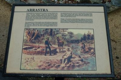
The Spanish first introduced the arrastra to the New World in the 1500's. The work “arrastra” come from the Spanish word “arrastre”, meaning to drag along the ground. When ore was quarried out of the hard rock mines, the quartz had to be crushed to free the gold. The arrastra was the earliest and simplest device introduced into the remote areas of the California Gold Fields to do this operation. The simplest form of the arrastra was a flat-bottomed drag stone place in a circular, rock-lined pit and connected to a center post by a long arm. With a horse, mule or person provided power at the other end of the arm, the stone dragged slowly around in a circle. Ore place between the stone floor and drag stone was crushed into a coarse powder after which water and quicksilver were added. The resulting slurry was removed to sluices (troughs) were the gold was recovered. Thanks to the efforts of the Stanislaus National Forest Groveland Ranger District, the title to the drag stone and all of the floor stones of this arrastra was transferred to the Groveland Yosemite Gateway Museum. It has been reconstructed by local volunteers. (Plaque typos preserved as printed; Groveland Yosemite Gateway Museum interpretive marker.)
The record
| Marker family | Other |
| County | Tuolumne County |
| Place | Groveland |
| Location | On Main Street (State Highway 120), on the right when traveling west; near the Groveland Library/Museum; at or near 18990 Main Street, Groveland |
| Coordinates | 37.839800, -120.226133 |