Nevada County
Meadow Lake – Excelsior
Other · Soda Springs · Nevada County, California
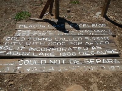
What the marker says
The granite dam was built 1858 for flumes of valley gold towns. Called Summit City with 2000 pop. after 1863. It incorporated as Meadow Lake 1866. Because gold could not be separated, it was abandoned 1872. B.S.A. Troop 46, Marin Council (part of the credit line is missing per the HMdb page). Erected by Boy Scout Troop 46.
The record
| Marker family | Other |
| County | Nevada County |
| Place | Soda Springs |
| Location | Tahoe National Forest Service Road 843, on the east side overlooking Meadow Lake near the southern end of the campground (access via Henness Pass Road and Forest Service Road 86) |
| Coordinates | 39.409650, -120.503167 |