Every road-trip idea Dave stumbles on — a reel, a link, a tip — gets captured here, checked just enough to be useful, and filed with its source, its season, and its distance from Fiddletown.
US550Colorado
19Great roads filed
14Worthy stops
8Candidate loops
11,018 ftHighest pass
~950 miFiddletown → flagship road
Late spr–fallBest window open
Exit 1 The Register — Roads
Status key: idea → shortlisted → routed → done. Everything below is at idea — captured, not yet routed.
The Register's first driven road — and it's a home one. Dave ran this paved forest road on Friday Nov 6, 2026: a two-hour outing in the rally MGB GT, between roughly 4,850 and 5,220 ft, through a fire-scarred stretch of standing snags and open sky, then over a bridge in deep green timber. Cabin country, not a big loop — the kind of road this Register exists to remember. Dave's route: a loop from the cabin — Shake Ridge Road to Highway 88, past Cook's Station and Ham's Station, Cat Creek to North-South Road, up Omo Ranch Road and back via 88 and Shake Ridge. Two named bridges are pinned on it: Cat Creek Bridge (his Nov 6 photo stop) and the Glenn Oviatt Bridge, a pony truss on North-South Road over the Middle Fork Cosumnes River — the loop's second water crossing is the river, not the creek. Route file: cat-creek-loop.gpx — 11 waypoints, ~66.3 mi, inRoute-ready.
Second source — The Traveling Dans, “1 highway, 10 national parks” (filed Nov 11, 2026): also named along the way — Cedar Breaks, Kodachrome Basin, Grand Staircase–Escalante, Montezuma Castle, Walnut Canyon, Wupatki, Sunset Crater. Their guidance: August to early October, driven north to south, at least 2 weeks.
The Utah Scenic Cluster — four roads off the US 89 spine
Two more from the same reel, at opposite ends of the Southwest: the park road under the Teton Range in Grand Teton (pairs with Lamar Valley, below), and the road through Valley of Fire State Park, Nevada — on the way in from the southwest.
The Register goes international — Ruby Tawes' “before you die” list
Three new roads, all outside the US: the Icefields Parkway, Banff–Jasper in Alberta · Highway 40, the Kananaskis Trail (the two pair as an Alberta Rockies cluster) · Mount Cook Road in New Zealand. The reel's other five — Teton Park Road, Going-to-the-Sun Road, Hwy 395, the Yosemite Valley Loop, Hwy 1 — were already filed here; it's now a second source on each.
The original Highway 95 grade above White Bird, Idaho, carved into open bluffs in 1921: ~2,900 vertical feet through 30+ stacked hairpins, most with no guardrails, looking down over the White Bird Battlefield — where the first battle of the 1877 Nez Perce War was fought. Filed as candidate material for a future Idaho / US-95 drive.
🌀 30+ hairpins · ~2,900 ft🗓️ Season not yet notedStatus · Idea
A 129-foot spring-fed falls in McArthur-Burney Falls Memorial State Park, near Burney — ~100 million gallons a day, year-round. Theodore Roosevelt called it the “Eighth Wonder of the World.” ~1.3-mile loop trail to the pool.
Historic Gold Country hotel in Dutch Flat, 1 mile off I-80 at exit 145 — on the Tahoe run. A detour stop, not a destination: the pitch is the food (burger, loaded baked potato, beer) as a reason to pull off.
The Sierra Railway's original shops — one of the last working steam roundhouses in the US. Guided roundhouse tours (call (209) 984-3953 for the day's times), belt-driven machine shop, working turntable, Sierra No. 3 (1891) and No. 28 (1922), 200+ film productions. Winter (Nov–Mar): park 10 AM–3 PM; excursion trains are Apr–Oct weekends. Holiday special: The Polar Express, Nov 27–Dec 20, Fri–Sun, 4:30 / 6:00 / 7:30 PM, $85. Admission $5 / $3.
🚂 Heritage railroad🗓️ Trains Apr–Oct · park year-roundIdea
Source: railtown1897.org — Dave's research request, filed Nov 12, 2026.
Narrow-gauge logging railroad ten minutes from Yosemite's south entrance — Shay steam locomotives and open-air log cars. The Logger Steam Train: 1-hour narrated, 4-mile round trip, daily Apr–Oct, up to 4 departures a day. Holiday special: Holiday Magic Train, select dates Nov 20–Dec 30, 4:00 / 5:30 / 7:00 PM, adults from $63.60 — dogs welcome, hot cocoa included. The Moonlight Special dinner train is summer only.
🚂 Heritage railroad🗓️ Season Apr–Oct + holiday trainsIdea
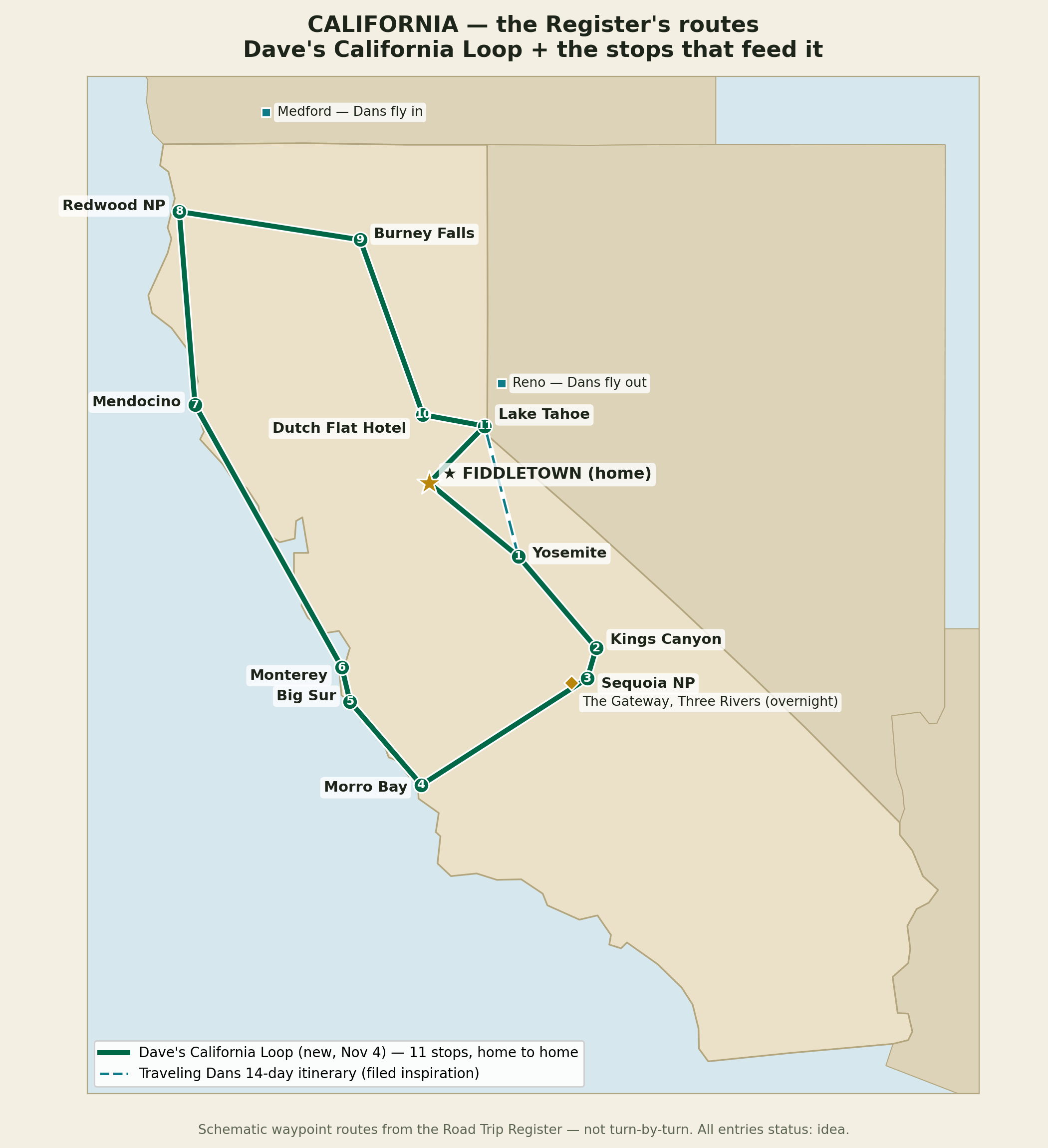
Best window: May–September. Their routing flies into Medford, OR and out of Reno, NV. Source: The Traveling Dans reel — sent by Dave, Nov 4, 2026. No itinerary built — inspiration only, per Dave's instruction.
🐻 Dave's California Loop (Dave's own — added Nov 4, 2026)
A true loop from home, assembled from stops already in this Register — my proposal skeleton, Dave's direction still to come. Season: May–September. Unlike the Traveling Dans itinerary, this one starts and ends at Dave's door and folds in Burney Falls and the Dutch Flat detour.
🏔️ The Washington State Loop (Ruby Tawes — filed as inspiration)
Inside those stops: Chain Lakes Loop · Ross Lake, Maple Pass, Diablo Lake · Franklin Falls, Barclay Lake · Fremont Lookout sunrise, Sunrise & Paradise · Forks, Neah Bay. Add-ons filed with it: Leavenworth, Columbia River Gorge (WA side), Mount St. Helens, Lake Chelan/Stehekin, Lake Wenatchee. Source: Ruby Tawes reel — sent by Dave, Nov 4, 2026.
🏜️ The Southwest Cluster (seed — a pairing note, not a routed loop)
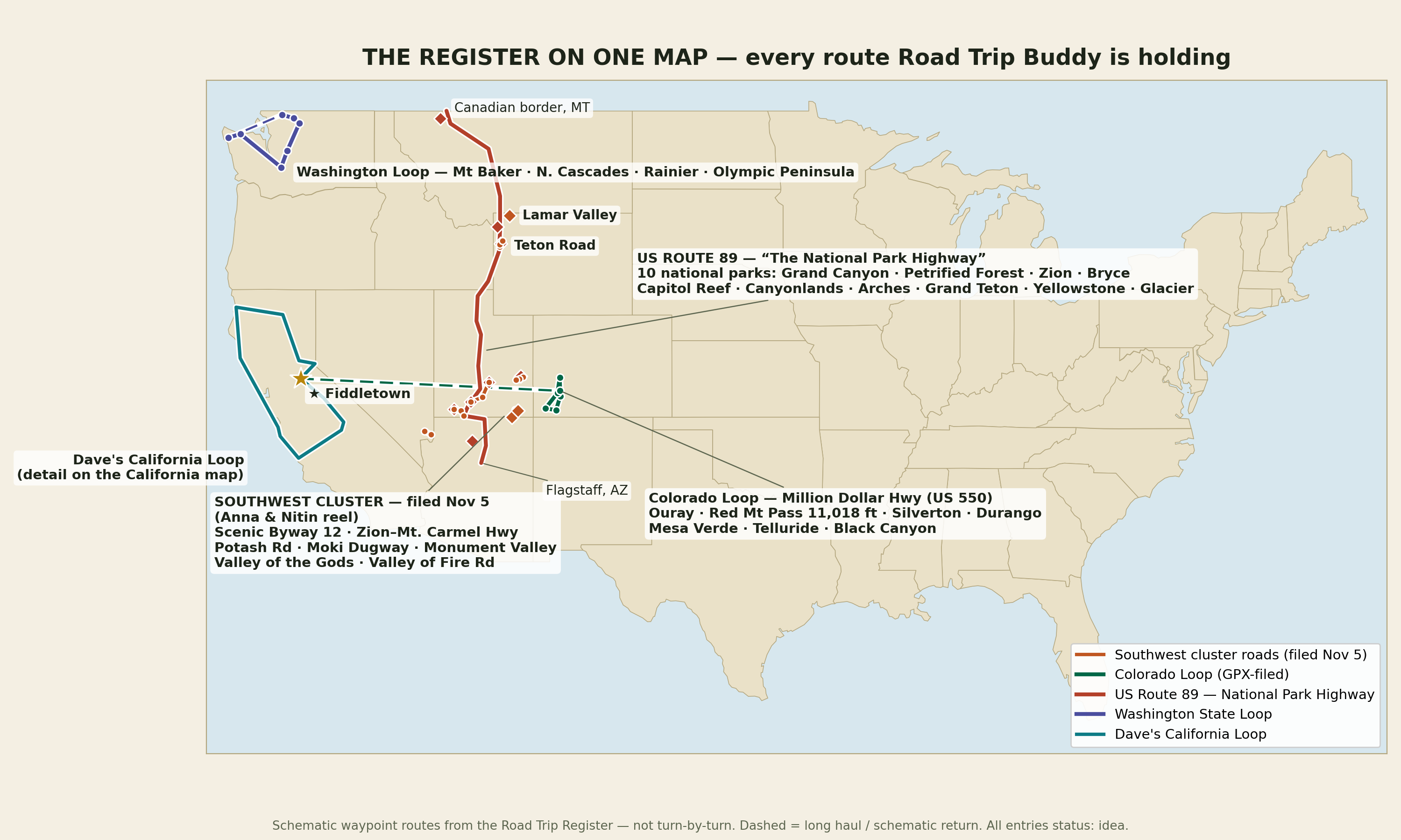
The Nov 5 Anna & Nitin roads hang naturally off the US 89 spine: Byway 12 + Zion–Mt. Carmel in park country, Potash Road at Moab, Moki Dugway + Valley of the Gods + Monument Valley in the southeast corner — with Teton Road + Lamar Valley at the north end and Valley of Fire on the way in. Filed as a seed only; no loop routed unless Dave asks.
🎿 Snowshoe Thompson Commemorative Drive (planned — Palm Sunday, Sun Mar 21, 2027)
Dave's project: retrace the mail run on the day Telemark honors Thompson with a memorial ski run. Placerville → US-50 → Echo Summit → Luther Pass → Hope Valley → Genoa, NV — his statue at Mormon Station, his grave in the Genoa Cemetery — then home on Hwy 88 west through Carson Pass, Ham's Station and Cook's Station. Participants carry the mail: commemorative envelopes picked up in Placerville, mailed from the Genoa post office. ~231 mi all-in — a full, honest day. Story: The Snowshoe Thompson Story; full draft plan in the repo.
A three-summit Sierra day: Cabin → Murphys → Calaveras Big Trees → Lake Alpine & Lake Alpine Lodge → Cape Horn Vista → Mosquito Lakes → Ebbetts Pass (8,736 ft) → Markleeville → Monitor Pass (8,314 ft) → Bridgeport (fuel) → Leavitt Falls → Sonora Pass (9,624 ft) → Kennedy Meadows → Columns of the Giants → Donnell Vista → Sonora → Cabin. ~401 mi; 12.5–13 h realistic driving (OSRM's 11.7 h is optimistic). All three passes verified open the morning of (Caltrans, Nov 11, 08:12 AM) — Ebbetts is on a temporary re-opening and the Nov 12–15 storm may close the passes for the season, so this run threads the needle. GPX: cabin-ebbetts-sonora-loop.gpx, 18 waypoints. 🍔 Burger edition also filed: cabin-ebbetts-sonora-burgers.gpx adds 8 burger pins (26 waypoints, ~403 mi) — Frosty (Angels Camp), Branding Iron (Murphys — listed closed Tue–Wed ⚠️), Giant Burger (Arnold), Cutthroat Tavern (Markleeville), The Barn + Jolly Kone (Bridgeport), Local Press (Twain Harte), Diamondback Grill (Sonora).
Exit 4 Someday — Events
Events Dave wants to attend one day, filed Nov 4, 2026.
An application-only, multi-day driving rally — a different scouted corner of the country each year (the Driftless, Appalachia, eastern Oregon's high desert, and one California run “behind the Redwood Curtain”). Night Zero + three days, no timing, no trophies; analog cars first, “take the car” is the mantra. Applications open in July and are read by hand — dates and locations come via their mailing list. Also theirs: Camp Overcrest at Monterey Car Week — car camping above Carmel Valley, the community-driven way to do Car Week.
Detour Standing Project — Every Road in Eldorado National Forest 🌲
Dave's Nov 9 goal: drive every road in the forest, paved and unpaved — little cars where the surface suits, high-clearance for the rough ones. Census built from the Forest Service MVUMs (2024), staged district by district from the cabin outward.
Forest-wide census complete — driven 2 of ~1,024
✅ Cat Creek Road (9N17) and North-South Road (10N83) — Nov 6 loop portions — plus Omo Ranch Road, a driven county connector. First targets awaiting Dave's pick: Ellis Road (8N25), paved-class, 8.55 mi · Panther Creek Road (8N05), paved-class, 11 mi (FS listed it closed/rough Nov 9 — verify first) · Mormon Emigrant Trail (10N50), paved, ~24.5 mi, winter-closed · high-clearance: Salt Springs (8N50), Bear River (8N03), Mehrten Spring (8N23) and the Panther/Ellis spurs. All four districts are now extracted from the 2024 MVUMs — Amador 267 · Georgetown 346 · Pacific 287 · Placerville 124 new — for a forest total of ~1,024 roads (honest range ~1,000–1,025 pending dedup at shared boundaries). Other districts' named drives: Ice House Road (Pacific, paved, ~30 mi to Loon Lake) and Wentworth Springs Road (Georgetown/Pacific). Full census: ELDORADO.md in the repo.
🌲 All 4 districtsProgress · 2 / ~1,024 roads
Source: USDA Forest Service MVUM, Amador Ranger District, 2024 edition; goal set by Dave, Nov 9, 2026.
Exit 5 The Register, Mapped
Schematic waypoint maps drawn from the Register itself — not turn-by-turn. The US map now includes the Nov 5 Southwest cluster (orange).
The whole Register on one map — Colorado Loop, US Route 89, Washington Loop, Dave's California Loop, and the Southwest cluster filed Nov 5.California in detail — Dave's California Loop, numbered, with the Traveling Dans 14-day itinerary dashed alongside.
Exit 6 How I Work
Capture: send me any reel, link, or tip — I file it in the Register with its source.
Check: season, rough distance from Fiddletown, and why it earns a stop — no invented facts; unknown means unknown.
Curate: ideas move idea → shortlisted → routed → done as Dave weighs in.
Hand off: a firmed-up trip goes to ✈️ Travel Buddy as a route skeleton.
🧠 Brain dump
Dump what's on your mind about Road Trip Buddy — raw and unfiltered. Each dump lands in the buddy's repo (docs/ingest.md) as a timestamped entry — or saves on this device until a repo is linked and a token is connected.
🔒 Connect GitHub to unlock dumping. Paste a token once — it stays on this device only.